320

Trails Reviewed

Find Trails & Maps

Search for Trail
Search by Location
Search by

Back to listing

Peninsula Point Interpretive Trail

Trail Details

County
Delta
Regions
Eastern Upper Peninsula
Latitude
N 45° 40' 44.76"
Longitude
W 086° 58' 2.64"
Distance
2.2 miles loop
Trail Type
Two-track and foot path
Terrain
Woods, meadows and Lake Michigan
Difficulty
Easy
Nearest City or Town
Rapid City
(map loads here)
view map
Part of the Hiawatha National Forest, Peninsula Point is a noted stopover for the annual monarch butterfly migration and the site of a historic lighthouse. Within it is Peninsula Point Interpretive Trail, a 1.2-mile footpath from the trailhead to the the watery views at the tip of the peninsula, best enjoyed from the top of the lighthouse tower. A return along a dirt two-track turns this pleasant hike into a 2.2-mile loop.
Expand All
Photos
Description
From mid-August through September Peninsula Point is known for “monarch madness.”

That’s when huge numbers of the distinctive orange butterfly migrate from Minnesota, Wisconsin and the Upper Peninsula south to Mexico, a 1,900-mile journey for an insect with a wingspan of less than four inches.

Waves of monarchs use the point as a staging area before attempting the long open water crossing of Lake Michigan. At the peak of the migration in early September a decade ago, you could witness 3,000 or more monarchs fluttering in a handful of trees at this Hiawatha National Forest day-use area at the end of Stonington Peninsula.

Since then, climate change and deforestation of the insect’s mountainous winter habitat in central Mexico have greatly affected the monarch population. It’s estimated that the Eastern species has declined by more than 80% since the 1980s, but it’s still an amazing migration. And it’s best seen today at Peninsula Point.

Can’t make it for the madness? Come whenever you can. This small spit of land, loaded with history, excellent birding opportunities and a lighthouse that you can climb for a watery panoramic of Lake Michigan, is worth a visit any time of the summer.

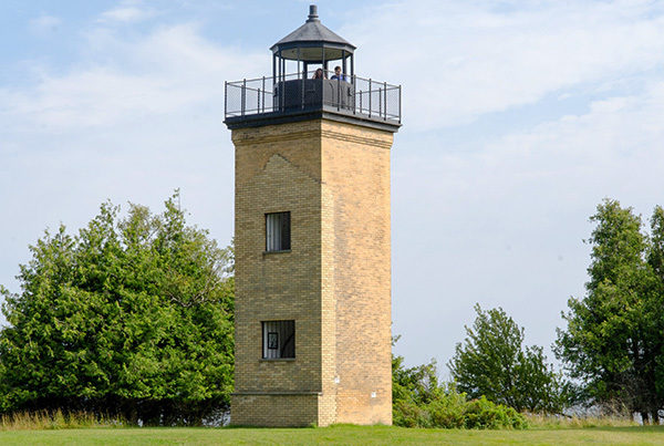
The centerpiece of the day-use area is Peninsula Point Lighthouse. The U.S. Congress authorized its construction in 1864 because wooden sailing ships, hauling lumber, iron ore, and fish from Escanaba, Gladstone and Fayette, were no match for the treacherous shoals that separated Big Bay de Noc from Little Bay de Noc.

The structure was built in 1865 and consisted of a 40-foot tower, lit by an oil lamp and reflectors and an adjoining home for the lightkeeper and his family. The light went out for the last time in 1936, but the view from the point was so spectacular that the U.S. Forest Service converted it into a public picnic area in 1937. The lightkeeper’s house burned to the ground in 1959, but the brick tower survived and today is listed on the National Register of Historic Places.

Peninsula Point is also an important migration stopover for birds traveling up the Lake Michigan shore. Spring migrations can be exceptional, a time when birders can sight more than 200 different species.

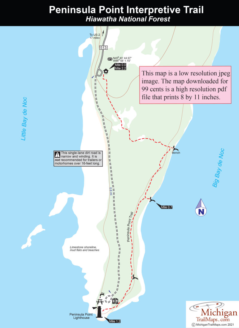
Much of the point is forested and winding through the trees or skirting the shoreline is an interpretive trail and a rugged single-lane dirt road. You can combine the two for a scenic hike, a 2.2-mile loop from the RV parking area at the end of the pavement to the picnic grounds that surrounded the lighthouse.
Amenities & Services
Difficulty - Easy
Dog Friendly
Trail Guide

There are two ways to reach Peninsula Point Lighthouse: you can drive to it or hike in. If you’re thinking about driving, be advised that the final mile of County Road 513 is a narrow, winding, and very bumpy one-lane road not recommended for recreation vehicles more than 16 feet long or vehicles pulling trailers.

Better to hike even if you don’t arrive in a motorhome.

The trailhead for the 1.2-mile Peninsula Point Interpretive Trail is in the RV parking lot and the footpath ends in a picnic area surrounding the historical lighthouse. Along the way it features a series of interpretive displays, ranging from how to find trilobite fossils and why the point is such a haven for birders to unique plants not found anywhere else in the Upper Peninsula.

Blue diamonds will lead you through tall grass, heavy bush and a fern meadow at the start into a cool cedar forest where it is easy to recognize the footpath. At Mile 0.5 the trail curves sharply east, and you’re rewarded with your first view of Big Bay de Noc and a bench to enjoy it.

You reach a second lakeshore bench with a better view of Washington Island to the south in a quarter mile and from here, the trail remains just inside the shoreline trees, providing shade and a constant view of the bay. At a third bench, the trail swings inland and pops out in the open picnic area at the end of the peninsula at Mile 1.2.

Built in 1865 and dominating the picnic grounds is the squarish Peninsula Point Lighthouse. You can climb the 40 steps to a 360-degree panorama at the top of the 40-foot tower that includes Escanaba State Forest to the west, the limestone bluffs of Fayette State Park to the east, and the length of Lake Michigan in front of you.

To complete the loop, follow the single-lane road that is CR-513 and leads a mile back to the RV parking lot. The narrow dirt road stays in view of Little Bay de Noc much of the way, passing stretches of limestone shoreline, mudflats with excellent birding and strips of sandy beach.

Facilities

Surrounding the lighthouse are picnic tables, grills, and vault toilets.

Hours & Fees

Peninsula Point is open year-round. There are no entry or vehicle fees to enjoy the interpretive trail or lighthouse.

Directions

From Rapid River drive 2.4 miles east on US-2 to County Road (CR) 513. Turn right (southwest) on CR 513 and drive 17 miles to the RV parking lot. Please note that the last mile of the road to the lighthouse is single-lane, narrow and winding. The road is NOT recommended for recreational vehicles (RVs) or trailers over 16-feet long or 8-feet high. Pull-offs have been provided in case you meet oncoming traffic. A parking area for larger vehicles can be found at the beginning of the final mile of the road.


Information

For more information, contact the Rapid River Ranger District Office (906-474-6442) of the Hiawatha National Forest located at 8181 US-2.


Geo-referenced maps from MichiganTrailMaps.com range from $1.99 to $2.99 each.

Download the Avenza app from the App Store or Google Play

App Store Google Play

Michigan TrailMaps.com Michigan's Premier Trail Resource Contact

Trail Mix News

by travel and outdoor writer Jim DuFresne!

Sign Up
Enews Signup
Find a Trail

Find Trails & Maps

Search for Trail
Search by Location
Search by