320

Trails Reviewed

Find Trails & Maps

Search for Trail
Search by Location
Search by

Back to listing

Petoskey State Park

Trail Details

County
Emmet
Regions
Northwest
Latitude
N 45° 24' 17.28"
Longitude
W 084° 54' 17.64"
Distance
0.5 to 1.5 miles
Trail Type
Foot and ski trails
Terrain
Sand dunes
Difficulty
Easy
Nearest City or Town
Petoskey
(map loads here)
view map
In the middle of the resorts, summer cottages, shopping areas and marinas that line Little Traverse Bay from Petoskey to Harbor Springs is Petoskey State Park. This 303-acre sanctuary may not be large but its amazing what it offers; some of the most secluded modern sites in the state, a beautiful beach, good hunting for Petoskey stones, and even a trail system.Originally of the W.W. Rice Company, the City of Petoskey purchased the land in 1934 and named it the Petoskey Bathing Beach. Eventually the city sold the beach to the State of Michigan and in July, 1979 the first campers arrived at Michigans newest state park. Theyve been arriving ever since as Petoskeys State Parks two campground ...
Expand All
Photos
Description

In the middle of the resorts, summer cottages, shopping areas and marinas that line Little Traverse Bay from Petoskey to Harbor Springs is Petoskey State Park. This 303-acre sanctuary may not be large but it’s amazing what it offers; some of the most secluded modern sites in the state, a beautiful beach, good hunting for Petoskey stones, and even a trail system.

Originally of the W.W. Rice Company, the City of Petoskey purchased the land in 1934 and named it the Petoskey Bathing Beach. Eventually the city sold the beach to the State of Michigan and in July, 1979 the first campers arrived at Michigan’s newest state park. They’ve been arriving ever since as Petoskey’s State Park’s two campgrounds are among the most popular in the region.

One of the most popular activities in the park is searching for Petoskey stones, the northern Michigan ritual of beachcombing and washing pebbles off in the Great Lake. Visitors stroll along the park's entire 1.25 miles of shoreline searching for the official state stone but many focus on the patches of pebbles and small rocks found at the south end. It takes a trained eye to spot the distinct coral pattern when the stone is dry, but they stand out in a handful of pebbles when held just under the clear surface of Little Traverse Bay.

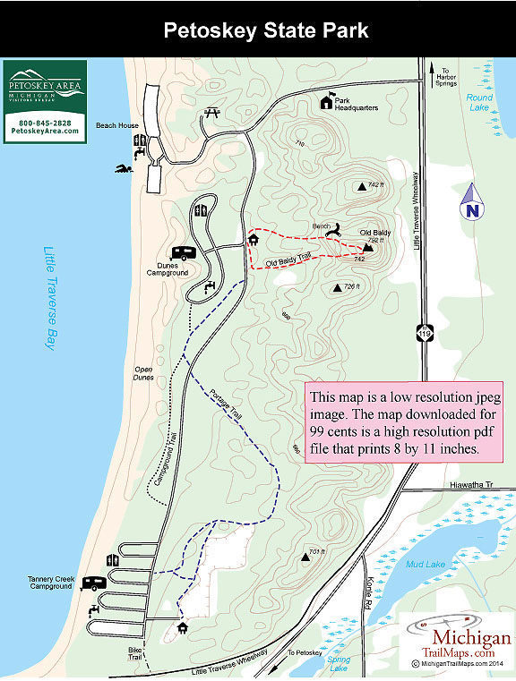
Away from the shoreline, the state park is a gently rolling to hilly area of old dunes covered mostly in deciduous forests along with small stands of conifers. Winding through the backside of the park is a limited trail system of 2.2 miles that includes Old Baldy Trail, a half-mile loop that climbs to the highest point in the park, passing an observation platform along the way.

But the park is connected to the Little Traverse Wheelway, a 26-mile paved trail that connects Harbor Springs to Charlevoix. In the winter Petoskey State Park, with its abundance of lake-effect snow, is popular among cross country skiers and snowshoers.

Amenities & Services
Camping
Difficulty - Easy
Dog Friendly
Foot Path
Groomed Classic Skiing
Trail Guide

Click on highlighted trails for individual trail page:

Old Baldy Trail 0.5 miles Hike
Portage Trail 1.0 miles Hike
Campground Trail 0.5 miles Hike
Bike Trail 1.4 miles Access Trail
Ski Trails 1.5 miles Nordic Ski

Facilities

The park has 168 sites divided between two campground loops. The Dunes Campground is the original facility and has 70 modern sites in a forested area of low dunes. For as close as they are to each other, these sites are as secluded as any modern campground you’ll find in a state park. The area is heavily forested and the terrain of rolling dunes allows most of the sites to occupy a little nook of their own. The loop is paved but not the spurs and large RVs might have difficulty with some of the sites.

Tannery Creek Campground is at the south end of the park and consists of four loops of 98 sites in a level, lightly forested area. Tannery Creek lacks that charming seclusion of the Dunes but four wooden walkways provide access to Little Traverse Bay and at this end the beach is a mixture of sand and pebbles, dismaying to swimmers but a paradise for Petoskey stone hunters. Both loops have restrooms with showers, sanitation stations, firewood bins and tables and grills at each site.

At the north end of the park is a shaded picnic area with tables and pedestal grills and the entrance to group campsites. Nearby is the beach and a marked swimming area. Here the shoreline is sandy, wide and enclosed by several dunes. There is a bathhouse/concession store and two parking lots that hold 300 vehicles. The view of the bay is pleasant as you look out over the entire body of water that is often dotted by the colorful spinnakers of sailboats.

Hours & Fees

There is a vehicle entry fee at Petoskey State Park, which is open year-round.

Directions

The park is 4.5 miles north of downtown Petoskey. Follow US-31 to M-119 and then north (left) for 1.5 miles to the posted entrance.

Information

Contact Petoskey State Park (231-347-2311) for information on trail conditions. To reserve a campsite contact the Michigan State Park Central Reservations (800-447-2757; www.midnrreservations.com). For lodging or other travel information contact the Petoskey Area Visitors Bureau (231-348-2755, 800-845-2828; www.petoskeyarea.com). For more information or a map to the Little Traverse Wheelway contact the Top of Michigan Trails Council (231-348-8280; trailscouncil.org).


Geo-referenced maps from MichiganTrailMaps.com range from $1.99 to $2.99 each.

Download the Avenza app from the App Store or Google Play

App Store Google Play

Michigan TrailMaps.com Michigan's Premier Trail Resource Contact

Trail Mix News

by travel and outdoor writer Jim DuFresne!

Sign Up
Enews Signup
Find a Trail

Find Trails & Maps

Search for Trail
Search by Location
Search by