320

Trails Reviewed

Find Trails & Maps

Search for Trail
Search by Location
Search by

Back to listing

Porcupine Mountains: Big Carp River Trail

Trail Details

County
Ontonagon
Regions
Western Upper Peninsula
Latitude
N 46° 48' 9.36"
Longitude
W 089° 45' 57.24"
Distance
9.6 miles
Trail Type
Backpacking trail
Terrain
Escarpment & Big Carp River
Difficulty
Challenging
Nearest City or Town
Ontonagon
(map loads here)
view map
Most people follow the Big Carp River Trail in Porcupine Mountains Wilderness State Park from east to west. Theybegin the day on a high rocky bluff overlooking the rugged landscape of an ancient mountain range. They endit on the shores of Lake Superior, the worlds largest freshwater sea. In between we followed an entire river from its beginning to its end.There are more than 2,000 miles of foot trails in Michigan but none quite like the Big Carp River Trail in the heart of this nearly 60,000-acre wilderness.This well-worn trail is a 9.6-mile hike from the mountains to the sea.It begins at the most popular spot in the park, the Lake of the Clouds overlook, and ends at one of the most remo ...
Expand All
Photos
Description
Most people follow the Big Carp River Trail in Porcupine Mountains Wilderness State Park from east to west. They begin the day on a high rocky bluff overlooking the rugged landscape of an ancient mountain range. They end it on the shores of Lake Superior, the world's largest freshwater sea. In between we followed an entire river from its beginning to its end.

There are more than 2,000 miles of foot trails in Michigan but none quite like the Big Carp River Trail in the heart of this nearly 60,000-acre wilderness. This well-worn trail is a 9.6-mile hike from the mountains to the sea.

It begins at the most popular spot in the park, the Lake of the Clouds overlook, and ends at one of the most remote, the mouth of the Big Carp River. In between there are thundering waterfalls, stands of virgin pine, a steep-sided gorge, black bears, bald eagles and brook trout.

The mouth of the Big Carp River and thus the west end of the trail is 4 miles from the nearest road and almost 10 miles from where you started. It's such a remote spot that most hikers make provisions to spend the night by either renting one of three wilderness cabins in the area or packing along a tent and staying in the backcountry campsites.

They turn the trail into a multi-day loop by following either Correction Line Trail or Little Carp River Trail to spend a night at Mirror Lake. The following day they hike the North Mirror Lake Trail back to their vehicle at the Lake of the Clouds overlook.
Amenities & Services
Camping
Difficulty - Challenging
Foot Path
Trail Guide

For a map or complete description to all the trails order Porcupine Mountains Wilderness State Park: A Backcountry Guide for Hikers, Backpackers, Campers & Winter Visitors by Jim DuFresne from the eshop:

From the Lake of the Clouds overlook, most hikers head east to walk the Escarpment Trail, a popular day hike in the park. Big Carp River Trail heads west and for almost 2 miles skirts the Escarpment, a 400-foot-high rocky bluff with alpine-like vistas and views of the park's rugged interior.

Within 30 minutes you reach the high point of the day at 1,447 feet. Here you can stand on the edge of the steep-sided ridge and look down to see where the Big Carp River emerges from Lake of the Clouds.

In the next mile, the trail follows the edge of this bluff, passing one spectacular view after another until arriving at a semi-open area. At Mile 1.5, you stand on the edge of a rock cliff and peer down a sheer drop to the Big Carp River in the valley below, a stunning sight. Or you can gaze west along ridge where beyond a gap in the cliff is Miscowawbic Peak in the foreground and 2 miles away LaFayette Peak, marking one end of the Escarpment. There are three backcountry campsites near by and it's easy to understand why they were placed here. This is a beautiful spot to set up a tent.

You resume following the bluff briefly then begin the long descent to the floor of the valley. It’s a half mile descent, sharp at first but gentle most of the way as you drop from the high point of the day of 1,447 feet to less than 1,100 feet. Along the way you move from a beech/maple forest to a stand of stately hemlock.

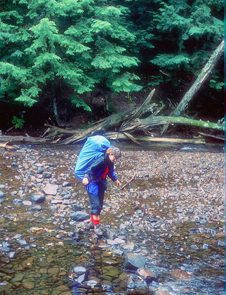
After viewing the Big Carp River from above, you finally reach the river just beyond Mile 5. This far upriver the Big Carp is 15 to 20 yards wide with a gentle flowing current that swirls through an occasional pool. Anglers would do well to drop their packs and scout the Big Carp up stream for brook trout.actually a large stream with a gentle current that swirls through a series of pools.

The Big Carp is forded and just down the trail at Mile 5.3 is the junction with Correction Line Trail. From here Mirror Lake is a 2.8 miles east and 600 foot climb along the Correction Line Trail.

Lake Superior is 4.3 miles to the west on the Big Carp River Trail which curves to the north to follow the river. Within 2 miles you pass through another impressive stand of hemlock and skirt the edge of a steep gorge until you are standing just downriver from Shining Cloud Falls.

Reached at Mile 8.2, the cascade is stunning, a powerful thrust of water that first explodes from between the narrow walls of the gorge and then drops 35 feet into the river. It's name comes from the ever-present cloud of mist that fills the gorge and creates rainbows on a clear day. Nearby is a backcountry campsite

In the final 1.4 miles you stay close to the river and pass another dozen cascades, all unnamed except the last one; Bathtub Falls. Bathtub is a series of small drops and pools; a giant, ice-cold Jacuzzi where hikers will often kick off their boots and soak their weary feet.

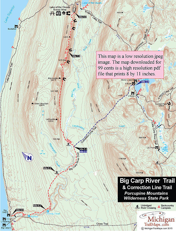
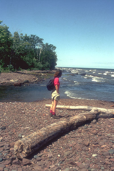
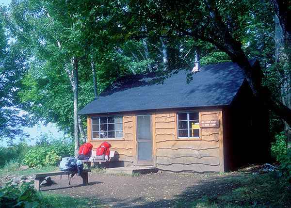
Big Carp River Trail ends where the river does, on the shores of Lake Superior at Mile 9.6. Located here are three wilderness cabins - Big Carp 6 Bunk, Lake Superior and Big Carp 4-Bunk - and three backcountry campsites in the area.

In the evening most backpackers gather at the mouth of the Big Carp River to watch the sun melt into the wide blue horizon that is Lake Superior.

Facilities

There are eight backcountry campsites along the Big Carp River Trail. At the mouth of the river are three wilderness cabins - Big Carp River Six-Bunk, Big Carp River Four-Bunk and Lake Superior. There are toilets but no source of drinking water at the Lake of the Clouds Overlook.

Hours & Fees

The three wilderness cabins - Big Carp River Six-Bunk, Big Carp River Four-Bunk and Lake Superior - are $65 a night and can be reserved six months in advance.The backcountry campsites are $15 a night and are used on a first-come-first-serve basis.

Directions

The trailhead of the Big Carp River Trail is at the Lake of the Clouds Overlook, reached by following M-107 to its west end.

Information

For more information call the park headquarters at (906) 885-5275. You can reserve cabins and yurts and register for a backcountry campsites through the Michigan State Parks Campground Reservation System (800-447-2757; www.midnrreservations.com).


Geo-referenced maps from MichiganTrailMaps.com range from $1.99 to $2.99 each.

Download the Avenza app from the App Store or Google Play

App Store Google Play

Michigan TrailMaps.com Michigan's Premier Trail Resource Contact

Trail Mix News

by travel and outdoor writer Jim DuFresne!

Sign Up
Enews Signup
Find a Trail

Find Trails & Maps

Search for Trail
Search by Location
Search by