For a map or complete description to all the trails order Porcupine Mountains Wilderness State Park: A Backcountry Guide for Hikers, Backpackers, Campers & Winter Visitors by Jim DuFresne from the eshop:
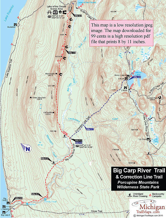
Named for the “correction line” cartographers use to adjust flat maps to the earth’s curvature, the trail departs from a junction reached a quarter mile after the Big Carp River Trail crosses to south side of the river. The first part lies in a low-lying forest that is notorious for being muddy even in fair weather. After a heavy rain, the mud can suck your boots right off your feet.
At Mile 0.7 you cross Landlookers Creek. Landlookers were timber cruisers hired by the lumber companies in the 19th century to search and map out stands of pine. Ironically, this is one section the lumber barons never touched as much of Correction Line passes through virgin stands of hemlock as well as impressive tracts of maples and yellow birch. Once across the creek, the trail begins it long climb to the higher level of the lake.
You climb 200 feet within 0.3 mile, arriving at a spot where the trail crosses a small creek to the other side of a ravine. Then you begin climbing again, this time along a much steeper section as Correction Line takes you quickly from 1,300 to 1,584 feet. At Mile 1.8 you top off on the edge of Big Carp River drainage filled with some of the finest hemlocks and maples in the park. In the fall, views of the valley below are possible and at times even impressive.
The trail levels out when it enters a small hollow of old growth timber enclosed to the north by impressive rock bluffs. The only thing more impressive is the mud. It gets deeper still. The natural inclination is to hike around the mud holes but that only makes the situation worse for others. It is really best to hike right through the mud and wash your boots at the end of the day.
The final half mile begins with a climb over a 1,617-foot knob and ends with the lake coming into view for the first time. A rapid descent puts you at Mirror Lake’s north shoreline and a posted junction with the North Mirror Lake Trail where the Correction Line ends. Lake Superior is 11.8 miles to the west via the Little Carp River Trail and the Lake of the Clouds Overlook is 4 miles to the east along the North Mirror Lake Trail. Head west on the North Mirror Lake Trail to pass the Two-Bunk Cabin and reach South Mirror Lake Trail to access the three backcountry campsites on the south shore of Mirror Lake. Head east on North Mirror Lake Trail to check out the other cabins and campsites.