320

Trails Reviewed

Find Trails & Maps

Search for Trail
Search by Location
Search by

Back to listing

Porcupine Mountains: Deer Yard & Superior Loop

Trail Details

County
Ontonagon
Regions
Western Upper Peninsula
Latitude
N 46° 49' 5.16"
Longitude
W 089° 41' 40.56"
Distance
3.5 miles
Trail Type
Mountain bike and Nordic ski
Terrain
Lake Superior, old growth forests
Difficulty
Easy
Nearest City or Town
Ontonagon
(map loads here)
view map
Deer Yard and Superior loops can be combined for a 3.5-mile ride that will be gentle on the mind and easy on the cardiovascular system. The loop may be limited in mileage but features two of the three rental cabins White Birch and Whitetail that can be accessed on a mountain bike. This ride begins with the Superior Loop at the winter trailhead across M-107 from the ski lodge and covers the perimeter of the system.There is also a trailhead 0.2 mile further west along M-107 while from the rental yurts in Union Bay Campground there is an access trail that leads west to Superior Loop.
Expand All
Photos
Description
Deer Yard and Superior loops can be combined for a 3.5-mile ride that will be gentle on the mind and easy on the cardiovascular system. The loop may be limited in mileage but features two of the three rental cabins – White Birch and Whitetail – that can be accessed on a mountain bike. This ride begins with the Superior Loop at the winter trailhead across M-107 from the ski lodge and covers the perimeter of the system.

There is also a trailhead 0.2 mile further west along M-107 while from the rental yurts in Union Bay Campground there is an access trail that leads west to Superior Loop.

 
Amenities & Services
Camping
Difficulty - Easy
Groomed Classic Skiing
Multi-use Trail
Trail Guide

For a map or complete description to all the trails order Porcupine Mountains Wilderness State Park: A Backcountry Guide for Hikers, Backpackers, Campers & Winter Visitors by Jim DuFresne from the eshop:

From the alpine ski area parking lot, cross M-107 to the winter trailhead on the north side of the road which marks an overgrown two-track. The Superior Loop heads south gently descending to Lake Superior and passing a junction with a crossover spur within a quarter mile and then the access trail to Union Bay Campground at Mile 0.4. It’s a quarter mile to the Union Bay West and East yurts.

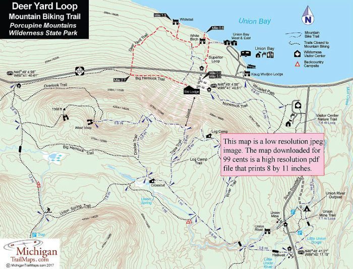
A quick descent follows before the trail swings to the west near the Lake Superior shoreline and arrives at the White Birch Cabin at Mile 0.6. White Birch Cabin is a warming shelter in the winter but utilized as a rental cabin the rest of the year. This snug, 2-bunk cabin features a fire ring, picnic table and log bench outside. It’s not within view of the water but nearby a short spur leads to the rocky Lake Superior shoreline, the perfect place to catch a sunset.

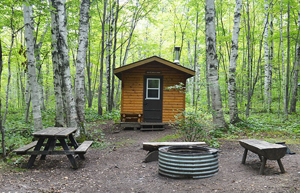
Superior Loop heads south from the cabin and within a quarter mile reaches a posted junction with Deer Yard Trail. Head northwest (right) to continue on a two-track to reach the junction to Whitetail Cabin just beyond Mile 1. The eight-bunk cabin is a couple hundred yards down a spur trail and features a view of the lake through the trees and access to its shoreline that is made up of steeply tilted sandstone layers.

Return to the main trail and continue west to cross a smallish stream and then venture through a towering stand of hemlocks at Mile 1.5. Impressive trees to say the least. Deer Yard Trail switches from a two-track to more of a cobblestone pathway, passes through a few wet areas and just before Mile 2 curves to the south.

What follows is a sustained climb to M-107. You cross the paved road (watch for traffic!) and continue the climb on the other side reaching a junction with Big Hemlock Trail at Mile 2.7 To the west (right) Big Hemlock is closed to mountain bikes. To the east (right) it's a long and fun downhill run to the ski lodge reached at Mile 3.5.

Facilities

Accessed from the trail system are two rustic cabins - Whitetail and White Birch - and two yurts, Union Bay West and Union East on the edge of Union Bay Campground. All of them should be reserved in advance.

Hours & Fees

A state park Recreation Passport or daily vehicle permit is required to enter the park and leave a car at the trailhead. Passes can be purchased from the park's Wilderness Visitor Center. Whitetail and White Birch cabins are $65 a night.

Directions

The best place to start is the large parking area for the alpine ski area along M-107, 1.3 miles west of South Boundary Road.

Information

For more information call the park headquarters at (906) 885-5275. You can reserve the cabins and yurts through the Michigan State Parks Campground Reservation System (800-447-2757; www.midnrreservations.com).


Geo-referenced maps from MichiganTrailMaps.com range from $1.99 to $2.99 each.

Download the Avenza app from the App Store or Google Play

App Store Google Play

Michigan TrailMaps.com Michigan's Premier Trail Resource Contact

Trail Mix News

by travel and outdoor writer Jim DuFresne!

Sign Up
Enews Signup
Find a Trail

Find Trails & Maps

Search for Trail
Search by Location
Search by