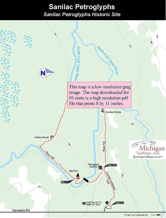
From the parking lot it’s a 0.25-mile walk along a crushed limestone trail to a large pavilion that has been built over the slab of sandstone. Most of the carvings—outlines of hands, animal tracks, birds, and spirals—are not visible at first glance. A display near the entrance shows their locations, and the best viewing is on overcast days when you can use a flashlight to illuminate the petroglyphs from the side.
But even children can guess the most prominent one—a bowman with a long, single arm depicting both his arm and arrow—and it’s fun trying to figure out what the rest could be. Deer? Hunters? Mythological creatures, maybe?
With such a great start to the walk, some young hikers head up the trail half expecting a tipi around every bend. There’s no tipis but a few steps from the rock carvings is where the “council circle” was located for a Chippewa tribe that once had a village here. Within a half mile from the start are surface rocks with large, round depressions believed to be mortars that Indians made to store and protect food. The mortars were easy to make—the Indians simply pounded the soft sandstone with round, hard rocks. Larger mortars are just down the trail at Thunder Rock.
At this point the trail curves south, close to South Fork Cass River, and passes through a lowland forest. The large maple trees arching over the river are impressive in the fall, but come spring this can be a muddy section. The moisture and mud, however, encourage a profusion of wildflowers in May and June, when the trails are crisscrossed with easy-to-identify deer tracks leading off in every direction.
In a little more than half mile from the pavilion, the trail crosses a swing bridge over the river; on the other side was the location of Temple Dorr’s cabin, a timber cruiser who lived here in 1835. Just up the trail is a rock outcropping where loggers once rolled logs down into the river to float them to the Saginaw mills. The trail passes some impressive birch trees and then emerges into a semi-open area for the remainder of the hike. It was in this area that the Chippewa village was located. As late as 1900 Indians from a Caro reservation spent the summer months here while they picked and dried wild berries. If you search around, you can find more mortars.
Just beyond Mile 1 is an impressive pine that is the lone survivor of the Great Fire of 1881, an event that closed the chapter on logging in Michigan’s Thumb region. From the Big Pine, great place for a snack, you return to the river and cross to the other bank on another swing bridge. The pavilion is now only minutes away and from there you backtrack to the parking lot.


