The Easy Loop
This 3.9-mile outing is often followed in a counter-clockwise direction with skiers enduring a mile-long climb of 250-foot climb in the first half. Skiers who follow the loop in a counter-clockwise direction enjoy an easier climb to Dunes Overlook but face a long downhill run on the return where more control is required to avoid run-away speed on the way to the covered bridge.
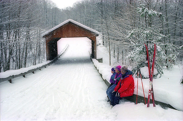
The loop begins at the back of the parking lot with a short portion of the Shauger Hill Trail to reach Scenic Drive. You pop out at a wide snow-covered road and follow it north to the V junction with the return traffic. Head right and at Mile 0.8 you pass the first crossover spur and then encounter a sharp downhill, bottoming out at the covered bridge. Be careful on both this hill and the bridge! The covered bridge is scenic but that roof limits the amount of snow inside.
Beyond the covered bridge is one long climb to Picnic Mountain and Dunes Overlook. The steepest segment ends at the Glen Lake overlook, a great place to catch your breath, and then at Mile 2.1 you arrive at a winter trail junction sign in the middle of Scenic Drive. Just beyond it is the parking area and short trail to the Dunes Overlook platform. Even if this area has been scoured of snow by steady Lake Michigan winds, don’t pass up the opportunity to clip out of your skis and walk the 500 yards to the viewing deck. The barren plateau of rolling dunes spread out in front of you is an amazing view in the winter.
At the Scenic Drive Ski Trail junction, you leave the roadway and head south on a much more narrow trail. This segment bypasses a mile-long stretch of road that winds through open dunes, includes two steep slopes, and doesn’t hold snow very well. The bypass is a gentle downhill run through the woods and within a third of a mile you return to the road and head left.
The gentle downhill run continues for another half mile until you return to the first crossover spur at Mile 3. Head left and backtrack the first mile to return to the trailhead parking lot. Head right to continue with Scenic Drive Ski Trail. To reach the Lake Michigan Overlook from this direction, skiers face two very steep uphill climbs.
Lake Michigan Overlook Loop
The overlooks at posts No. 9 and No. 10 along Scenic Drive are as dramatic in the winter as they are in the summer, making them popular destinations for skiers and snowshoers after the first snowfalls. There is no direction of travel on Scenic Drive Ski Trail, but the vast majority of people follow a counter-clockwise loop to avoid having to herringbone up a pair of steep hills on the backside.
From the north end of the winter trailhead parking lot, you can follow a short segment of Shauger Hill Trail to reach the unplowed roadway and then continue a half mile to the V junction where you head left for the overlooks.
Many skiers, however, begin at the posted trailhead at the south end of the parking lot and add the southern half of Shauger Hill Trail, an easy route for most skiers, for a 4.1-mile outing. Twice this trail crosses Shauger Hill Road, an unplowed two-track in the winter and at Mile 1.4 arrives at a posted junction. To the right is the challenging second half of Shauger Hill Trail. To the left is a crossover spur that climbs gently for a quarter mile to Scenic Drive Ski Trail, where you pop out near post No. 12.
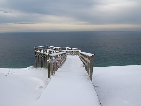
Scenic Drive continues the gentle climb to the left, reaching North Bark Lake Overlook in a quarter mile and Lake Michigan Overlook parking area at Mile 2.4. From the parking area, the view that is post No. 9 is a short climb, but this entire area usually has sand mixed with the snow. If that’s the case, kick off the skis and walk to the edge of the perched dune where below will be a shoreline of jumbled ice. With caution, you can also continue to the observation platform to see the Manitou Islands to the northwest.
From Lake Michigan Overlook, Scenic Drive swings to the south and in less than a mile descends almost 200 feet in a pair of long downhill runs. At Mile 3.3, you bottom out at a crossover spur. To the right, the crossover spur gently descends into the woods for a third of a mile to return to Scenic Drive just west of the V junction in the roadway. The remaining half mile back to the parking lot is an easy ski along the unplowed roadway and a short segment of Shauger Hill Trail.