
Sleeping Bear Dunes: The Dunes Trail

Buy the $.99 downloadable map!
(This map is not geo-referenced)Buy the Geo-referenced map
for use in the Avenza Maps App
Trail Details
Geo-referenced maps from MichiganTrailMaps.com are available through Avenza Maps and range from $1.99 to $2.99 each.
Download the Avenza app from the App Store or Google Play


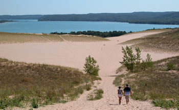


Most visitors are content with just climbing the dune, but departing from this picnic area are two trails. Skirting the base is the Duneside Accessible Trail, a paved, interpretive path. Departing from the top of the Dune Climb is the Dunes Trail, a 1.8-mile trek across the perched dunes to Lake Michigan.
During the summer a steady stream of hikers follow the Dunes Trail – via a series of blue-tipped posts - but unfortunately many of them start out shirtless, hatless, and, worst of all, shoeless, and never reach beautiful Lake Michigan at the end. They soon discover that trudging through soft sand up steep dunes in the hot sun is not the same as walking down a beach.
This hike is challenging. If you have trouble scaling the Dune Climb at the beginning think twice before continuing on as you will have to climb five more dunes of various heights. Halfway out to the lake you’ll be greeted with a view of South Manitou Island from the crest of a dune and should be able to even see its 100-foot-high lighthouse marking the entrance of Manitou Passage.
But for those who come prepared with walking shoes, sunglasses, a wide-brimmed hat, sunscreen, and water, the Dunes Hiking Trail can be a most unusual trek during the summer. The rolling dunes are beautiful and vary in cover from open sand or patches of beachgrass and wildflowers to a lone cottonwood here and there. The hike is a workout for many people, but the isolated beach along Lake Michigan and its refreshing surf is a great place to recuperate before heading back along the same route.
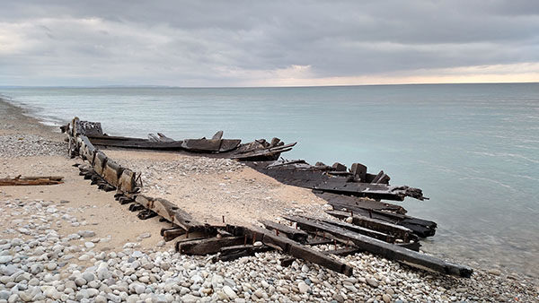
A recent addition of this trail is a shipwreck that doesn't require scuba gear to view. In 2014, a November storm left behind the biggest shipwreck ever to appear on the park’s mainland shoreline, measuring 14 feet wide and 43 feet long and includes ironwork. Historians believe it is part of the James McBride, built in 1848 and lost in October 1857. The remains of the wreck are on Lake Michigan 300 yards south of The Dunes Trail.
| Difficulty - Challenging |
| Foot Path |
Geo-referenced maps from MichiganTrailMaps.com range from $1.99 to $2.99 each.
Download the Avenza app from the App Store or Google Play
