Missouri Top Trails State! Show Me Why
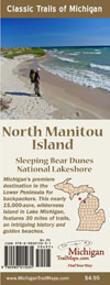
North Mantiou Island Map
Back by popular demand MichiganTrailMaps.com is staging its holiday sale again. Order a book and we’ll throw in one our trail maps, a $4.95 value!
Order any book from our e-shop — maybe Isle Royale National Park: Foot Trails & Water Routes, Backpacking In Michigan or 12 Classic Trout Streams in Michigan for that fly fishing friend of yours, and make sure you fill in the “Autograph Book For” section with who you want author Jim DuFresne to dedicate it to or what to write.
In the same area also let us know which map to send you. It could be Jordan River Pathway, Manistee River Trail or our newest maps; South Manitou Island or North Manitou Island. You’ll receive a personalized Christmas gift for somebody and a detailed map for your adventure next summer. All at a very affordable price.
By Jim DuFresne

Jim DuFresne
News flash! Missouri was named this year the “Best Trails State” by American Trails, a nonprofit organization working on behalf of the nation’s hiking and biking trails.
Really?
The Show-Me State “boasts” almost 1,000 miles of trails in its state park system, 700 miles of trail through Mark Twain National Forest and another 500 miles of National Recreation Trails as designated by the U.S. Department of Interior. Its crown jewel is the Katy Trail, which extends 240 miles along the Missouri River and is the longest developed rail-trail in the nation.
Excuse me if I don’t book a flight to St. Louis tomorrow.
Let’s start with the facts. Did you know that Michigan has more than 12,000 miles of recreational trails? Of these, 560 miles are forest looped trails, 905 miles are bike trails across the state and 900 miles are in our state parks. We may not have the longest rail-trail in the country but we have the most rail trails, 2,623 miles that weave a web across both peninsulas.
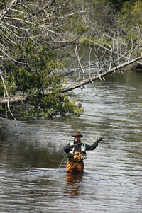
A fly angler on the South Branch of the Au Sable River in the Mason Tract.
And when it’s completed from North Dakota to New York, the North Country Trail will be the longest trail in the nation at approximately 4,600 miles. Of that Michigan has the most, 1,150 miles, along with the North Country Trail Association headquarters which is dedicated to finishing it off.
I’d also put our natural scenery, which is what makes a trail great, up against anything Missouri has to offer. We have 11,000 sparkling lakes, 36,000 miles of rivers and trout streams and the Great Lakes, which gives us more coastline than any other state except Alaska. We have so much water — and it’s fresh water — that the furthest you can be from a river bank or shoreline in Michigan is less than 6 miles.
Okay, we don’t have mountains in Michigan. Not real ones with peaks that exceed 2,000 feet in elevation. But we have sand dunes. Lots of them.
In fact, the western shore of Michigan’s Lower Peninsula features the most extensive collection of freshwater sand dunes in the country. These mountains of sand can tower more than 450 feet and border Lake Michigan, one of the largest and sweetest lakes you’ll ever dip your toes into. That combination of sand and surf allows us to end a day watching the sun melt into a sea of blue.
The dunes are also the destination for some of the most unique hikes not only in Michigan but the Midwest. Maybe even in the country. That elevation along with sandy peaks devoid of trees or thick brush gives way to endless views and panoramas that you’d expect on a mountain ridge. And more often than not most hikes in Michigan’s dune country include a stretch of pristine Lake Michigan beach with golden sand that is free of crowds, condos and beer coolers.
Does Missouri have that?
I‘m not sure of the criterion that American Trails uses to award “Best Trails State” and I have never been hiking or mountain biking in Missouri. I’m also pretty sure they don’t have much cross-country skiing in the Show Me State.
Still it’s hard to imagine Missouri has trails that exceed the beauty of these gems in Michigan:
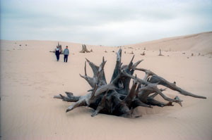
A ghost forest (trees killed by migrating dunes) in Silver Lake State Park.
Silver Lake Dunes: On one side of Silver Lake, it’s touristy with water slides, go carts and souvenir shops. On the other it’s nothing but dunes. Giant dunes that in places are so lacking of vegetation it’s like a scene from a Star Wars movie. It’s a round-trip hike of two miles across the heart of these dunes to a stretch of Lake Michigan so remote you can call it your own for an afternoon.
The Dunes Trail: The first mountain every three-year-old in Michigan conquers is the Dune Climb, a pure sandy slope that rises 130 feet above a parking lot in Sleeping Bear Dunes National Lakeshore. At the top is the start of the Dunes Trail which winds two miles over a series of large, grassy dunes to Lake Michigan. Most people then backtrack to their car. But for a far more interesting hike continue north by following the shoreline around Sleeping Bear Point where you can watch freighters floating effortlessly across the Great Lake or look for pieces of 19th century shipwrecks just off the beach. Within 6 miles you arrive at the historic Sleeping Bear Point Lifesaving Station, the perfect place to end this maritime trek.
Lakeshore Trail: A 42.5-mile, five-day journey through impressive sand dunes, past shipwrecks, and along the famed Pictured Rocks as you hike from Grand Marais to Munising. This is the crowning jewel of the entire North Country Trail and our most stunning trail in Michigan, a pilgrimage that every backpacker needs to make at least once in their life.
Mason Tract Pathway: Splitting the 4,493-acre Mason Tract in half is the South Branch of the Au Sable River, a blue ribbon trout stream that is steeped in fly fishing history. Paralleling the west bank is the Mason Tract Pathway, an 11.5-mile trail where the river moves in and out of view for most of the way. In May and June you can watch trout rise to afternoon hatches, in the winter the pathway is a wilderness adventure on snowshoes or backcountry skis.
The Greenstone Trail: Michigan’s classic 42-mile walk from one end of the largest island in Lake Superior to the other in Isle Royale National Park. Scenic views from high points, great backcountry campgrounds and the possibility of spotting a moose make this an excellent choice for a backpacking adventure. How remote is Isle Royale? You can only arrive by boat or float plane.


your comparison of Missouri and MI trails… very convincing!
The recognition of Missouri is largely an acknowledgement of the remarkable efforts of the Ozark Trail Association to revive and further the neglected vision of the Ozark Trail. The OTA has marshaled hundreds of volunteers, raised hundreds of thousands of dollars, coordinated multiple land agencies, and lead the way to completion of 225 miles of contiguous trail through prime Ozark terrain. It’s a great resource for hikers, bikers, and riders around the Midwest.
That said, I think Chapel Beach still is the most scenic spot between the Rockies and the eastern ranges.