325

Trails Reviewed

Find Trails & Maps

Search for Trail
Search by Location
Search by

Back to listing

Orion Oaks: Perimeter Loop

Trail Details

County
Oakland
Regions
Southeast
Latitude
N 42° 45' 55.80"
Longitude
W 083° 17' 54.24"
Distance
4-mile loop
Trail Type
Multi-use trail
Terrain
Wetlands, ridge, Lake Sixteen
Difficulty
Moderate
Nearest City or Town
Lake Orion
(map loads here)
view map
Departing from the Clarkston Road trailhead, the 4-mile Perimeter Loop is a modified version of the park's former Achievement Trail. But it’s shorter. there's backtracking, and avoids the popular dog. The solid four-mile hike in Oakland County that still includes all of the park’s most interesting corners, including the impressive boardwalk pines and the park’s 1,100-foot high point.
Expand All
Photos
Description
Most of the perimeter of the trail system in Orion Oaks County Park was once posted as the Orion Oaks Achievement Trail, a 6.2-mile loop that began at the parking area and trailhead off of Joslyn Road. The “achievement” of this route wasn’t hiking 6 miles, most avid walkers have few problems with that, but the fact that in the middle of Oakland County, generally a beehive of development in most parts, here was a place where you can hike a healthy distance in a completely natural area. That is quite an achievement for anybody living in metro Detroit.

The park trail system, however, with its many short spurs and crossovers, not to mention 34 numbered posts, was a bit confusing. In 2025, the system was shortened and simplified and now  includes only 21 intersection posts. The 4-mile Perimeter Loop is a modified version of the Achievement Trail that begins at Post No. 10 at the Clarkston Road trailhead. It’s shorter by eliminating the one-way spur to the southside of Lake Sixteen, avoids the popular dog bark but still includes all of the park’s most interesting corners, including the impressive pines between posts No. 14 and No. 7, the backside of Lake Sixteen and the park’s 1,100-foot high point.

On many days there will be as many mountain bikers on the trails as there are hikers and in the winter snowshoers and cross country skiers arrive even though the trails are not tracked and groomed like they are in nearby Indepedence Oaks County Park.

Overall, these trails are moderately easy. Fast hikers can cover it in 90 minutes. Mountain bikers even less time. But why hurry? On a pleasant day this is a great outing that includes many places to stop and enjoy the scenery in front of you; whether it’s the clear waters of Lake Sixteen, wildflowers bursting in color throughout a wetland in the spring or a partial view from the ridge in late fall or winter.
Amenities & Services
Difficulty - Moderate
Dog Friendly
Mountain Bike Single Track
Multi-use Trail
Trail Guide

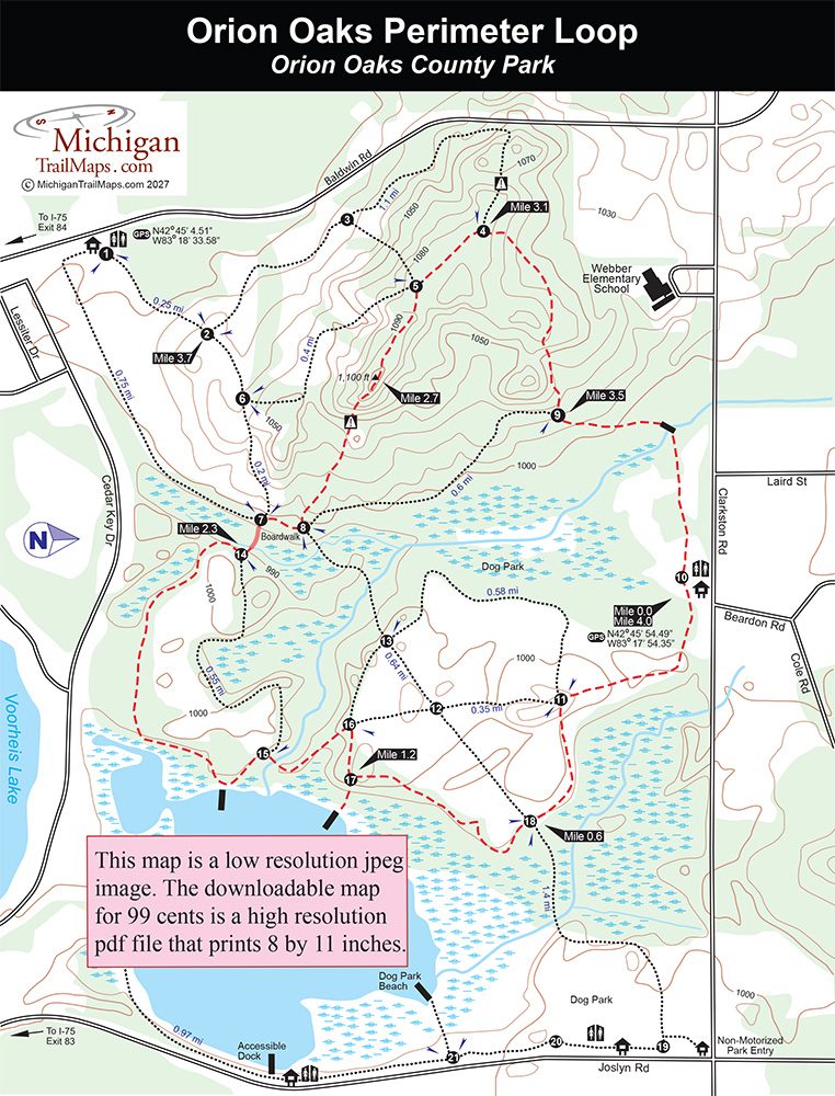
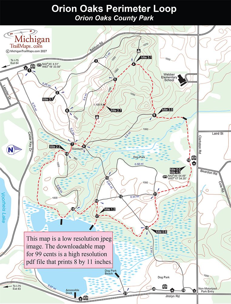
This loop begins at post No. 10 at the Clarkston Road trailhead where you will find a vault toilet. Head east (left) from the trailhead as the trail quickly swings south (left) passes through the wood chip storage area and at Mile 0.3 reaches post No. 11. Follow the route towards post No. 18 as it continues to skirt the woods and arrives at the spur from the Bark Park within a half mile from the start.

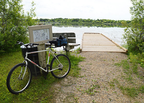
At post No. 18, this route swings south and skirts a marshy area, arriving at post No. 17 at Mile 1.2. The post marks a short spur to one of the fishing docks on Lake Sixteen. In less than a half mile you pass a second dock just beyond post No. 15. At either one you can soak up the scenery or spy on anglers in the lake trying to hook a trophy bluegill.

At this point the Perimeter Loop continues south until it reaches the border of the park where it swings west. You pass the roof tops and backsides of homes of Cedar Key Subdivision, not exactly what you want to see during a hike in the woods, but this is Southeast Michigan.

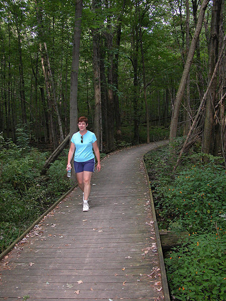
The trail quickly swings north and arrives at post No. 14, at Mile 2.3. Here you head west (left) and use a 120-foot boardwalk to cross through a marshy area past some huge pines that makes you feel like you’re somewhere in northern Michigan, not suburbia Oakland County. The boardwalk leads to Post No. 7 and here you head north (right) to quickly reach post No. 8. Follow the first trail to the left and get ready to climb. For the next quarter mile, you ascend 100 feet up the central ridge that dominates western half of the park until you reach 1,100 feet at Mile 2.7. This “peak” is not only the Orion Oak’s highest point but one of the highest in the area. During most of the year, foliage blocks any view but if the leaves have dropped or it’s early spring you can peer to the north and see Oakland County\'s other mammoth mountain; Pine Knob, complete with chairlifts. Alpine country in Oakland County.

The trail continues in its northwest direction to steadily descend to post No. 5 and then post No. 4 reached at Mile 3.1. Head east (right) at the junction to climb and then descend a wooded slope off of the central ridge to post No. 9. To the left the Clarkston Road trailhead is only a half mile to the south.

Facilities

Orion Oaks is a relatively undeveloped park, especially compared to nearby Independence Oaks County Park. There is a small boat launch off of Joslyn Road for non-motorized boats on Lake Sixteen along with three fishing docks on the lake including one that is wheelchair accessible.

Hours & Fees

Orion Oaks Bark Park opened in 2000 to the delight of dog owners everywhere. It’s now the most popular section of the park. The 44-acre, fenced-in area is one of the largest in Michigan and features two main trails, a field training area, benches, restrooms for people, “poop bags” for their pets. But its most unusual feature is a dog-only swimming area on Lake Sixteen.

Directions

From I-75, depart at exit 83 and head north on Joslyn Road to reach the lake access and trailhead on the east side of the park. Depart at exit 84 and head north on Baldwin Road to reach the trailhead on the west side. Continue on either road to reach Clarkston Road. From Baldwin turn right (east) to reach the Clarkston Road parking area, from Joslyn Road turn left (west).

Information

Contact the Independence Oaks County Park (248-625-0877) or the Oakland County Parks website.


Geo-referenced maps from MichiganTrailMaps.com range from $1.99 to $2.99 each.

Download the Avenza app from the App Store or Google Play

App Store Google Play

Michigan TrailMaps.com Michigan's Premier Trail Resource Contact

Trail Mix News

by travel and outdoor writer Jim DuFresne!

Sign Up
Enews Signup
Find a Trail

Find Trails & Maps

Search for Trail
Search by Location
Search by