For a map or complete description to all the trails order Porcupine Mountains Wilderness State Park: A Backcountry Guide for Hikers, Backpackers, Campers & Winter Visitors by Jim DuFresne from the eshop:
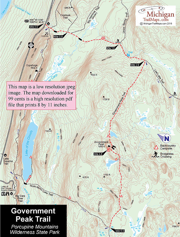
From the M-107 trailhead you begin with a steep climb to quickly pass the posted east end of the Escarpment Trail and then the first trailhead to the Overlook Trail. The trail levels out somewhat and then descends to the second trailhead of the Overlook reached at Mile 0.6.
Government Peak continues south and crosses through a low-lying forest, a level but often wet and muddy stretch. At Mile 1 you use a bridge to cross Upper Carp River for the first time, a sluggish stream in a marshy area. But all this changes in a half mile. The trail cuts across the wide bend where the river swings west, and when it returns to the Upper Carp you are climbing through an old growth forest with a mountain stream gurgling alongside of you.
This is very scenic gorge-like area at Mile 1.5 includes are a pair of backcountry campsites with fire rings and view of the river. You continue to climb into the gorge for the next half mile passing the posted junction with Union Spring Trail is reached at Mile 1.8. By heading east on this trail you can reach the natural spring in 2 miles and South Boundary Road in 4 miles.
Government Peak continues climbing south and passes several scenic pools with the best one, Trap Falls, reached 0.3 mile from the junction. The cascade is well named as the Upper Carp tumbles 15 feet down a narrow rock ledge into a basin below that traps the river momentarily in a deep pool before letting it continue. A bench in a stand of towering pines completes this scenic spot but on a hot summer day you will find that many backpackers would rather sit in the pool than on the bench.
Government Peak Trail continues by climbing a small hill and then descends to the junction with Lost Lake Trail at Mile 2.6. At this point Government Peak swings west and begins its second half as a fairly level route. Within a mile the trail climbs a series of low ridges and crosses several small streams that are often dry during mid-summer. After the third stream, the trail levels out and at Mile 3.9 you break out at an open marsh with a large beaver pond in the middle. Overlooking the pond is a backcountry campsite.
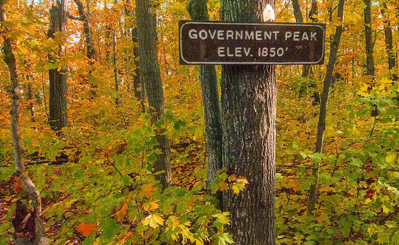
Beyond the pond, the trail immediately begins its ascent to Government Peak. It's a steady climb up and steep at times, but at Mile 4.8 you reach the peak where its elevation of 1,850 feet is posted near the stone foundations of a 1927 fire tower. The peak is reached 2.2 miles from the Lost Lake Trail junction and for most backpackers the view is anticlimactic. To the southwest, however, it is possible at times to gaze through the trees at the interior of the park including Summit Peak. There is a backcountry campsite near the peak and another on its west side.
Descending the peak to the west begins as a rapid downhill hike but overall not the steep slope experienced on the east side. Within a half mile you bottom out at a small creek that also feeds the Upper Carp River and is the location of a backcountry campsite. From there the trail is a level walk in the woods for the remaining 2 miles. This is where the trail can really be obscure and sometimes very muddy in places.
At Mile 6.1 you pass a backcountry campsite and within a quarter mile cross a small stream that is actually the headwaters of the Little Carp River. At Mile 6.9 you arrive at the posted junction with North Mirror Lake Trail.