Georeferencing, Smartphones and the Future of Trail Maps
 MichiganTrailMaps.com is proud to announce the addition of georeferenced maps for smartphones to its stable of trail maps. Following is a Trail Talk blog by Jim DuFresne on why we did it and how to download the new maps.
But DuFresne also wondered if hikers and backpackers need or even want all this technology out in the woods. Or as he writes “All this made me wonder if someday we’ll not even look at a map, simply listen to a voice telling us to turn left at the next trail sign or that there is a traffic jam a quarter mile away due to a moose in the middle of the path.”
The focus of our first batch of maps is Isle Royale. You can check them out on our website and even download their non-georeferenced counterparts still for only 99 cents. Under the Trail Guide tab just click on the trail you’re interested in at the park.
By Jim DuFresne
I was touring Ireland when I realized my wife was map illiterate.

Jim DuFresne
We had rented a car for two weeks but because she was uncomfortable driving on the left side of the road, I had to man the steering wheel the entire trip. Because I was too cheap to pay an additional $15 a day for a GPS unit, she had to navigate using paper maps.
They were good maps, produced by the various tourist associations around the country, but I quickly learned that my wife lacked basic mapping skills. She struggled with orientating the maps, identifying landmarks on them, judging distance using the scale bar and, in general, just couldn’t tell me which way to turn despite staring at a detailed drawing of the streets.
Who could blame her? My wife is first generation Google Maps. Or MapQuest or whatever mapping app you use. Most times she doesn’t even look at the map on her phone but merely follows the driving instructions that Siri, Alexa or whoever is telling her the quickest route possible.
And she’s not alone. It seems today that hardly anybody has a paper map in their car much less the 120-page, oversized DeLorme Michigan Atlas & Gazetteer that I have in the backseat. Or the 20 or 30 county and city maps stuffed in my glovebox.
I’ve been in a car with friends who wondered how to get to a restaurant and it didn’t matter that I told them (repeatedly sometimes) I knew the shortest route because I’ve been there a dozen times. They still didn’t trust me as much as that nameless Australian voice on Google Maps.

Backpackers double checking their location on a map at Isle Royale National Park.
I can’t win and we can’t stop high tech.
But I always figured following trails, especially backpacking in remote areas, would be the last bastion of paper maps if for no other reason than you couldn’t connect to the Internet. Or get a signal from the Global Positioning System satellites. Or your battery didn’t have enough juice to make it back to your car.
Getting involved with a start-up developing highly detailed trail maps for Michigan seemed like a safe bet. And it was for 10 years.
But high tech, paper-less maps has caught up with MichiganTrailMaps.com and old backpackers like me. This year MTM has begun producing georeferenced trail maps that you can download onto your oversized smartphone even when standing at the trailhead.
It was not an easy decision.
It first required investing substantially in the software – in our case MAPublisher from Avenza – to add georeferencing to our existing trail maps and to include it as a feature on our maps in the future.
And then a trip to Denver, home of such recreational mapping companies as National Geographic’s Trails Illustrated, to learn how to use MAPublisher. Sitting behind me in the class were two U.S. Geological Survey employees. Next to me was a guy who worked for the Department of Defense. Yea, it was that complicated.

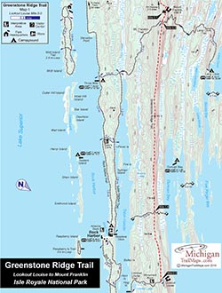
One of the new Isle Royale maps from MichiganTrailMaps.com.
Somehow, I survived and at MTM we began by producing georeferenced maps to simple trails in Oakland County. The first time I field tested one of the maps and watched that blue dot move along the trail on my phone as I hiked, well let me tell you, it was like having a come-to-Jesus moment at a Baptist tent revival. I was immediately converted.
Then MTM got serious. We contracted another cartographer from City Lake Maps and Charts in Minneapolis to help us begin producing a series of georeferenced maps to the 160-mile trail system at Isle Royale National Park.
These are the most detailed maps ever produced of the park. They measure 8 by 11 inches when printed and the 42-mile Greenstone Ridge Trail across the island required six of them.
Actually, we produced two sets of maps. From the MichiganTrailMaps.com website, you can download a non-georeferenced Isle Royale map for 99 cents, the same price as all our other downloadable maps.
From the Avenza Map Store, you can download the same map but for $2.99 because it features georeferencing. The Avenza Map Store is a mobile map app that allows you to download maps for offline use on iOS or Android smartphones or tablets. You would need to first download the app, if you don’t already have it, and then go to the MichiganTrailMaps.com landing page to download our maps.
It’s important to note that while you need the Internet to download a map onto your mobile device you don’t need it after that, which is good because getting the Internet on Isle Royale is tough if not impossible. You need a GPS signal but that is far easier to obtain in the middle of Lake Superior.
Also coming soon on our Avenza store are “map bundles,” a series of maps that work seamlessly together. The first is the Greenstone Ridge Trail, all six maps for a reduced price of $8.99. The second is the park’s Minong Ridge Trail, three maps for $5.99. More are to follow.
Ironically, MTM isn’t generating any additional revenue from georeferenced maps and sometimes less than our standard 99-cent maps. That’s because Avenza, the Toronto-based company that developed the software and map store app, takes a third of the retail price of each map sold. Apple or Google take another third as they always do with apps.
 And because we couldn’t justify selling a georeferenced map of a short trail for $2.99, we reduced the price for all those 3 miles or less to $1.99. You can do the math on that decision.
All this made me wonder at times if we need such technology on the trail. If someday we’ll be like my wife and not even look at a map, simply listen to a voice telling us to turn left at the next trail sign or that there is a traffic jam a quarter mile away due to a moose in the middle of the path.
Aren’t we strapping on a backpack for the simplicity of the lifestyle as well as to see a place we can’t reach in a car? Aren’t we trying to escape technology; i.e. Facebook, YouTube, text messages and Venmo?
I don’t know, that seems like a late-night discussion around a campfire. What I do believe is that this is the future of trail maps and either MTM stays up with it … or withers away.

