320

Trails Reviewed

Find Trails & Maps

Search for Trail
Search by Location
Search by

Back to listing

Porcupine Mountains Wilderness State Park

Trail Details

County
Ontonagon
Regions
Western Upper Peninsula
Latitude
N 46° 48' 53.64"
Longitude
W 089° 37' 29.64"
Distance
Trails range from 1 to 17 miles
Trail Type
Foot trails, cross-country ski trails, mountain bike trails
Terrain
Porcupine Mountains
Difficulty
Easy to challenging
Nearest City or Town
Ontonagon
(map loads here)
view map
Porcupine Mountains Wilderness State Park, the beloved Porkies to many backpackers, is not only Michigan’s largest state park at 59,020 acres but it’s also the most rugged and the wildest. The Porkies are laced with almost 110 miles of trails that wind past cascades, streams full of brook trout, 63 backcountry campsites, 18 walk-in cabins and yurts and a nearly endless number of panoramic views that rival anything seen south of the Mackinac Bridge. The hiking in the park ranges from easy day hikes to a five-day backpacking loop where every night is spent in a different rustic cabin.
Expand All
Photos
Description
Porcupine Mountains Wilderness State Park, the beloved Porkies to many backpackers, is not only Michigan’s largest state park at 59,020 acres but it’s also the most rugged and the wildest. In the Porkies you have the state’s third highest peak, a healthy population of black bears and an area large enough to contain entire rivers, 25 miles of Lake Superior shoreline, and the only ridges rugged enough in Michigan we can possibly call mountains.

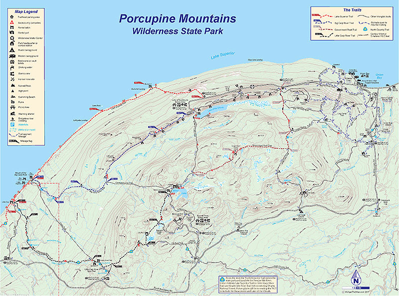
You can drive around the perimeter of the park and to its most famous viewing point, the Lake of the Clouds overlook. But to experience the heart and soul of Michigan's only state-designated wilderness you need to lace up your hiking boots, leave your vehicle behind and follow a trail into the backcountry.

The Porkies are laced with almost 110 miles of trails that wind past cascades, streams full of brook trout, 63 backcountry campsites, 18 walk-in cabins and yurts and a nearly endless number of panoramic views that rival anything seen south of the Mackinac Bridge. The hiking in the park ranges from easy day hikes to a five-day backpacking loop where every night is spent in a different rustic cabin. But the trait all trails share is that inevitably at some point you’ll be climbing. Sometimes quite steeply. These are, after all, the Porcupine Mountains. Make sure you boots are well-worn and your pack is light.

The trail system includes the Lake Superior Trail, the park’s longest path stretching 17.1 miles along the lakeshore. The Big Carp River Trail is one of the most amazing trails in Michigan because you follow a river from start to finish. The 9.6-mile trail begins on the Escarpment where below you can look down and see the beginning of the Big Carp River, a sluggish stream pouring out of Lake of the Clouds.  You eventually descend the rocky bluff to the river and in the final 4 miles follow it to where it empties into Lake Superior, one of the most remote spots in the park.

The Big Carp River Trail is often combined with the Little Carp River Trail for a four-day loop. At 11.8 miles Little Carp River is the second longest trail in the park and extends between two of the park’s most stunning lakes; Mirror Lake and Lake Superior. In between the trail skirts its namesake river, passing numerous waterfalls and cascades and winding through stands of giant old growth pines.

Dayhikes are also plentiful and include the spectacular Escarpment Trail. The Escarpment is a 4-mile point-to-point route that skirts the rocky bluff to views of Lake of the Clouds and then the Upper Carp River. All around you will be the ridges that are the Porcupine Mountains, painted in shades of autumn in late September and early October. At the west end of the park is the East and West River Trails that parallel the Presque Isle River, forming a 2.7-mile loop where boardwalks and viewing platforms place you right above the turbulence and three major waterfalls.

In the winter the Porkies is best known for its 320-acre downhill ski area whose slopes overlook Lake Superior, providing the park with the finest powder in the Midwest. Located just west of the park headquarters on M-107, the facility includes 15 groomer runs with a vertical drop of 600 feet and serviced by a triple chair lift, a double chair, a double T-bar and tow ropes. The longest run, Sunset, departs from the double chair and winds 1.2 miles through the words before returning the chalet at the base.

Fanning out from the downhill ski area is a 42-kilometer network of cross country ski trails through a terrain that ranges from rolling to very hilly. The runs are groomed and tracked and vary from Deer Yard Trail, a 4.8-kilometer loop with views of Lake Superior, to Union Spring Trail, an 19-kilometer run. The East and West Vista Trails pass a pair of 1,400-foot highpoints with stunning views of Lake Superior or Lake of the Clouds.

In the summer and fall most of the park’s cross-country ski trails are open to mountain bikers, who often combine portions of the Union Spring Trail with Log Camp and Rivers Trails for a 12-mile loop of adventurous riding. Highlights include the views from East Vista, following the Union River and the possibility of renting a rustic cabin for a night that you can ride to.
Amenities & Services
Camping
Difficulty - Challenging
Difficulty - Easy
Difficulty - Moderate
Dog Friendly
Foot Path
Groomed Classic Skiing
Mountain Bike Single Track
Trail Guide

For a map or a complete description to the trails order Porcupine Mountains Wilderness State Park: A Backcountry Guide for Hikers, Backpackers, Campers & Winter Visitors by Jim DuFresne from the eshop:

Click on highlighted trails for the individual trail page:

Lake Superior Trail 17.1 miles Backpack
Big Carp River Trail 9.6 miles Backpack
Little Carp River Trail 11.8 mile Backpack
Government Peak Trail 6.9 miles Backpack
Escarpment Trail 4.4 mile Day hike
Overlook Trail Loop 3.5 mile Day hike
South Mirror Lake Trail 3.0 miles Backpack/day hike
North Mirror Lake Trail 3.8 miles Backpack/day hike
Lily Pond Trail 2.3 miles Backpack/dayhike
Lost Lake Trail 3.4 miles Backpack/day hike
Beaver Creek Trail
1.2 miles Day hike
Pinkerton Trail
2.6 miles Backpack/day hike
Cross Trail
4.5 miles Backpack
Union Mine Trail 
1.1 mile Interpretive trail
Union Spring Trail 
4.0 miles Backpack/ski
Big Hemlock Trail
4.5 miles Ski
East-West Trails Loop 
2.7 miles Day hike 
Summit Peak Tower Trail 
0.5 mile Short trail
Visitor Center Nature Path 
1.4 miles Interpretive trail
Nonesuch Mine Trail 
1 mile Short trail
Deer Yard Trail 
3.5 mile Dayhike/mountain bike/ski
Correction Line Trail
2.8 miles Backpack
Superior Loop
1.2 miles Short Trail/mountain bike/ski


Facilities

The Porcupine Mountains have 19 wilderness cabins for rent throughout the park. Six structures; White Birch and Whitetail on Lake Superior, Union River, Crosscut, Log Camp and Gitche Gumee Cabin just off M-107 are rented year-round. The rest of the cabins are rented from April 1 through November. There are also four yurts, Mongolian-style wall tents with bunks, that are rented year-round.

Scattered throughout the park are 65 backcountry campsites that are outfitted with metal fire rings, a bear pole in many cases - but not all - and possibly even an open-air vault toilet. There are 20 sites along the Lake Superior Trail, with seven more on the shores of Mirror Lake, five on Lake of the Clouds and 12 stretched along the Little Carp River Trail.
To ease overcrowding in the backcountry, the Michigan DNR eliminated dispersed camping in 2018 and instilled a registration system for the trailside campsites. Backpackers now must register in advance for specific sites before entering the backcountry and stay at those designated sites once they are on the trail.

It is strongly recommended that visitors reserve backcountry campsites well in advance for the peak season; June through August. Backcountry reservations (www.midnrreservations.com; 1-800-44PARKS) are available six months in advance for May 15 through Oct. 14 to 72 hours before arrival at the park. If there is availability after you arrive, you can get a permit for an open backcountry campsite that day. The nightly cost to camp is $20 for up to 6 people.

Reservations will also be available online at Michigan State Park Online Reservations (www.midnrreservations.com) or by calling the Central Reservation Service at 1-800-44PARKS.

The park also has two large campgrounds, Union Bay, a modern facility with a 100 sites, and rustic Presque Isle with 50 sites, as well as three small outpost camping areas along South Boundary Road.

Hours & Fees

All vehicles must have either a $6 daily pass or a $11 annual state park Recreational Pass. All cabins, yurts and sites in Presque Isle and Union Bay Campgrounds can be reserved up to six months in advance through the Michigan State Park Online Reservations (800-447-2757; www.midnrreservations.com). Cabins and yurts are $65 a night, modern campsites $18-27 and rustic sites $15.

Backcountry campsites are $15 a night for up to four people. You can now reserve these in advance but you still pay for the sites when you pickup your backcountry permit at the park’s Wilderness Visitor Center on South Boundary Road just south of M-107.

Directions

The east entrance to the state park is reached from M-107, 16 miles west of Ontonagan and 3 miles west of Silver City. The west entrance is reached by County Road 519 that departs US-2 at Wakefield and in 15 miles ends at Presque Isle Campground on Lake Superior. In between the two is South Boundary Road that skirts the southern edge of the park to provide access to campgrounds, trailheads and scenic areas.

Information

The first stop for visitors just arriving at the Porcupine Mountains should be the park\'s impressive Wilderness Visitor Center, located a half mile south of M-107 on South Boundary Road. Inside there are exhibits explaining the geological history of the mountains plus a three-dimensional relief map that every backpacker should study before striking out. There is also a room devoted to,the diverse wildlife in the park and a small theater where,multi-slide presentations are repeated through out the day. The center is the best source of maps and trail information on the backcountry. It is open from open daily from 8 a.m. to 6 p.m. (ET), from mid May through mid October and during the summer months it has a list of vacant cabins available for last-minute rentals.

For information in advance contact the Porcupine Mountains Wilderness State Park headquarters (906-885-5275) or the park\'s Wilderness Visitor Center online at  www.michigan.gov/porkiesvc. For more information about downhill skiing at the Porcupine Mountains go to www.porkiesfun.com.


Geo-referenced maps from MichiganTrailMaps.com range from $1.99 to $2.99 each.

Download the Avenza app from the App Store or Google Play

App Store Google Play

Michigan TrailMaps.com Michigan's Premier Trail Resource Contact

Trail Mix News

by travel and outdoor writer Jim DuFresne!

Sign Up
Enews Signup
Find a Trail

Find Trails & Maps

Search for Trail
Search by Location
Search by